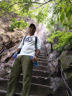
Mt.Huashan - April 2018
Mt.Huashan - Needless to say it is very beautiful and Strenuous hike.
My Hike Route: Start Yuquan Temple (645AM) -> (3.5 Hrs) North Peak -> (2 Hrs) East Peak -> (1 Hr) South Peak -> (0.5 Hrs) West Peak -> (1.5 Hrs) North Peak -> (1.5 Hrs) Down to bus stop by Stairs.
Total time : 13 Hours Fitness level: Medium.
Stayed at Huashuan FengGuang inn on Friday Night. Paid about 13 USD on Ctrip.com.
Started at 630AM from hotel.
645: Reached ticket office. Paid 360 for two of us.
It was foggy and pleasant. The climb starts steadily and not many steps. It is well paved.
We go past several scenic points and took pictures. There are many stalls all along the way.
I carried just two bottles of water, to keep the weight low. I bought 4-5 bottles at different spots and made
them add salt in water to replenish my body. Had lot of water melon as well.
After a couple of hours you will hit the steps. It is just the beginning :-)
You will see some steep ones and onew with chains. We could see the peaks above us with clouds and fog.
The scenery is amazing. Snapped a lot of pictures.
10 AM:Reached North peak. THis is where the people who took North Cable car will join.
In retrospect, I should have taken cable car as it would have save energy as from North peak covering peaks and back will take 6 hours.
Spent about half hour enjoying the views.
1230: Reached East Peak, from North to East Peak, it took 2 hours. You can see the Golden lock pass. Took some pictures.
It gets really beautiful and more difficult. At East peak there are several spots and viewing deck.
We went to "Chess Pavilion". There was a bit of a crowd and it took 45 minutes wait time.
YOu need to rent a haress. To go down, there are piegeon holes carved into steep rock.
We have to find and place both feet into same hole, before grappling to find the hole below.
View was magnificent with clouds sweeping across the valley. By the time we came back to the top, it was 245.
By this time, I started to get cramps. I had to take water melon and salt.
330: Reached South Peak. Highest point of mountains. View was great as always. I could see the west peak from here.
There are several points for taking pictures. I was drained by this time and was crying inside.
There was a long line for the "Plank in the Sky". Its not dangerous, but annoying to wait and share the ladder down to the plank.
We skipped due to time constraint and going to Chess Pavilion gave enough adrenalin rush.
400: Reached West Peak. It was cloudy and view was still good. I just wanted to get down at this point. My initial plan was to take
the West cable car down, but as fate would have it, Cable car was not running that day. Our option was to catch the North cable car.
We started back to North peak hoping to catch the North cable car.
545: Reached north peak. The line at the Cable car was very long. They estimated it would be atleast two hours waiting in queue.
So we decided to drag our butts down the hill. It is nothing but steps. It took around 2 hours to get down. There are no scenic spots on this routes.
745: Reached bus station. Got in bus and started to hotel near terracotta village.
After 13 hours of hiking, we were tired and just wanted to hit the bed.
TIPS: Start early to avoid crowds. Unless, you are super athlete, The route I did is very tough. At the end it becomes more painful as we are tired. Best is to go up via cable car up and down. One can still hike 4-6 hours on top. Plank walk and Chess Pavilion takes a lot of time. Be prepared to wat


Comments
Post a Comment